

A Guide to Transforming Construction Monitoring with Drone Mapping
Ever wished you could see your entire construction site from above—without climbing scaffolding or booking a helicopter? That’s exactly what modern drone technology makes possible. Welcome to the future of construction monitoring, where aerial surveying and advanced drone mapping techniques are changing how contractors, developers, and project managers track progress.
This isn’t just about cool gadgets—it’s about efficiency, safety, and smarter decision-making. In this guide, we’ll break down how drone mapping works, why it’s becoming essential in construction, and how Gig City Drones is helping Chattanooga’s construction industry reach new heights.
What is Drone-Based Aerial Surveying?
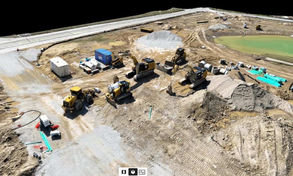
Imagine drones as more than just flying cameras. These UAVs (unmanned aerial vehicles) are equipped with high-resolution sensors that capture thousands of overlapping images of a job site. Using advanced mapping software, these images are stitched together to create precise digital maps and models.
The result? A detailed, bird’s-eye view of your project that’s not only visually impressive but also incredibly useful for planning, monitoring, and problem-solving.
Drone Mapping Basics
Here’s how drone mapping typically works:
Flight Planning: The drone follows a pre-programmed route, ensuring full coverage of the site.
Image Capture: Multiple overlapping photos are taken to eliminate blind spots.
Data Processing: Specialized software creates georeferenced orthomosaic maps and 3D models.
Actionable Insights: Construction teams use these maps for progress tracking, material calculations, safety checks, and more.
Mapping Techniques for Construction Monitoring
Different mapping techniques unlock unique insights for builders and developers:
Orthomosaic Mapping – Creates high-resolution, to-scale aerial maps of your site for accurate progress monitoring and reporting.
3D Modeling – Produces interactive 3D models, helping teams visualize structures, detect potential conflicts, and communicate project updates with clarity.
Thermal Imaging – Detects heat variations in materials, roofs, or electrical systems, allowing contractors to spot hidden issues like leaks, insulation problems, or faulty wiring.
Benefits of Using Drones for Construction Monitoring
Drone mapping isn’t just high-tech—it’s highly practical. Here’s why more construction companies in Chattanooga are adopting it:
Improved Safety – Reduce the need for workers to enter hazardous zones by letting drones handle inspections.
Faster Results – Large job sites can be surveyed in minutes, not days.
Cost Savings – Less manpower, fewer delays, and more accurate data mean real savings.
Better Accuracy – Advanced drone sensors deliver highly precise data, reducing errors in planning and execution.
Gig City Drones: Chattanooga’s Drone Mapping Experts
At Gig City Drones, we specialize in bringing the power of drone technology to construction sites across Chattanooga and surrounding Tennessee areas. Our services include:
High-resolution aerial photography & videography
Orthomosaic maps for accurate site documentation
3D construction site models for better planning
Thermal drone inspections to uncover hidden problems
With a skilled team of FAA-certified drone pilots and cutting-edge equipment, we help construction professionals save time, cut costs, and boost safety while gaining unmatched project insights.
Conclusion
Drone mapping is more than a trend—it’s a transformation in how construction projects are managed. From detailed aerial maps to real-time site insights, drones deliver the accuracy, efficiency, and safety that modern construction demands.
Ready to take your construction monitoring to the next level? Contact Gig City Drones today and discover how aerial surveying can give your projects a true bird’s-eye advantage. Together, let’s build smarter, faster, and safer—one drone flight at a time.